Improving interactions with customers: using GIS within a Customer Experience Strategy
In this customer story, we look at how Walsall Council’s Customer Experience Strategy has been bolstered by the use of GIS.
Walsall Council’s Customer Access Management (CAM) and Enabling Technology (ET) workstreams sit in its Proud Transformation programme. These workstreams work together to improve the way Walsall interacts with its customers.
These workstreams also underpin Walsall’s Customer Experience Strategy 2021-2026 and help council officers make their budgets stretch further.

Walsall’s Proud Promises
Walsall’s use of GIS supports the three promises at the heart of Walsall’s work:
1
IMPROVE OUTCOMES
& CUSTOMER EXPERIENCE
2
IMPROVE CUSTOMER SATISFACTION
& ENGAGEMENT
3
IMPROVE SERVICE EFFICIENCY
& PERFORMANCE
Using a Core Technology Platform (CTP) to underpin Customer Relationship Management
Using MS Dynamics 365 CE and other technologies, including Logger from Astun, Walsall has built a CTP with reusable components. These include case logging, address search, pay, notifications and mapping. These are linked to create two repeatable service patterns: Report IT and Request IT.
GIS IN ACTION
Report IT: enabling residents to report issues online
Report IT enables residents to report issues via the council website at a time and location that suits them.
As users have already logged accurate reports Customer Experience Centre (CXC) staff are freed up to concentrate on resolving issues. The web mapping component, provided by Logger, is essential to many of these processes.
Logger takes away the need for customers and the CXC to decipher ownership details. This is the start of the automation of the report being delivered to the relevant service area within Walsall.
USER-FRIENDLY LOCATION IDENTIFICATION
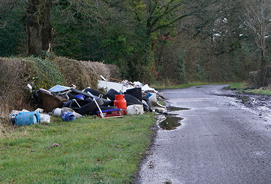
Residents using location-enabled mobiles can drop a pin exactly where they spot an issue, such as fly-tipping or a dead animal. This is a lot easier for residents than trying to work out the relevant postcode to use.
If an issue has already been logged, the user will be unable to submit a report. This prevents duplicate reports from clogging the system.
As reports are more accurate, field workers are able to conduct remediation work more efficiently.
BEHIND-THE-SCENES
VALIDATION
Existing GIS layers are used as constraint or context layers. If Walsall is not responsible for fixing an issue, Logger’s validation rules enable the customer to be gently deflected at the first point of contact.
For example, users can’t report potholes on private roads or fly-tipping on private land.
Some of the Report IT functions available to Walsall’s website visitors
Users can report a multitude of issues with increased accuracy, such as:

Animals
Animal fouling
Avian flu
Dead animals on public land

Anti-social behaviour
Abandoned or empty houses
Graffiti
Abandoned vehicles Needles/syringes/broken glass

Waste & litter
Problems with litter and litter bins
Street cleaning problems
Fly-tipping
How Report IT improves the customer experience
Tracy Lister, Walsall’s Strategic Geospatial Development and Support Manager,
outlines six key benefits:
Convenience
Users can report issues or make requests 24/7 without having to wait in a phone queue. Reports can be made anonymously for safety.
Ease of use
It’s easier for users to identify locations using maps, especially if they are using location-enabled mobiles.
Less frustration
Residents can only report issues which the council is responsible for rectifying.

No time-wasting
Residents can see if an issue has already been reported. If it has, they are prevented from making a duplicate report.
Accessibility
Each web page signs users to alternative ways of reporting an issue, e.g. via our Connected Hub.
Community
Reporting encourages a feeling of shared stewardship and pride in the environment.
GIS IN ACTION
Request IT: empowering residents to make requests online
Each year, various teams within Walsall receive thousands of requests. Turning requests into a digital process removes the need for residents to phone the council during office hours.
The Request It process gives council officers access to a customer’s information, as well as a spatial reference to the location of the Request It. This is much more efficient than checking through lengthy email trails or dealing with unnecessary telephone conversations. As a result, officers have more time to process reports and transfer them to the correct teams for resolution.
Here are some stats showing the potential impact of enabling residents to make requests online:
FREEING UP STAFF FOR MORE MEANINGFUL CONVERSATIONS
Over the years, 3,000 customers have telephoned the council to request a replacement bin. Reducing the number of calls frees up staff time to focus on those who need further support.
REDUCING WAITING TIMES
Over time, more than 4,000 customers have emailed or telephoned the council to apply for a bigger bin. Using the CRM reduces customer waiting times as they can access the request service whenever they wish.
News & views
Read our latest blogs
We’re twenty! Happy birthday to us!
Find out what our current team were up to back in 2005. What was the latest tech? Had they even seen a GIS in action? We reveal all!
Read moreWebinar Wednesday: Generating Simple Web Maps with Spotlight
Don’t worry if you missed the webinar. We’ll publish the video on YouTube after Easter!
Read moreElena’s expanding expertise: data, cloud, and community at Astun
Find out about Elena’s progression from Metadata Consultant to Data Services Engineer.
Read more


